


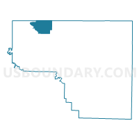
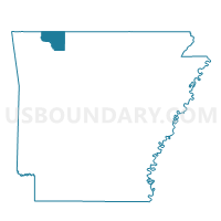
Holiday Voting District, Carroll County, Arkansas
About
Outline

Summary
| Unique Area Identifier | 526071 |
| Name | Holiday Voting District |
| County | Carroll County |
| State | Arkansas |
| Area (square miles) | 14.83 |
| Land Area (square miles) | 14.69 |
| Water Area (square miles) | 0.14 |
| % of Land Area | 99.05 |
| % of Water Area | 0.95 |
| Latitude of the Internal Point | 36.48170240 |
| Longtitude of the Internal Point | -93.71299110 |
Maps

Graphs
Select a template below for downloading or customizing gragh for Holiday Voting District, Carroll County, Arkansas


Neighbors
Neighoring Voting District (by Name) Neighboring Voting District on the Map
- Beaver Voting District, Carroll County, AR
- Golden Voting District, Barry County, MO
- Johnson Springs Voting District, Carroll County, AR
- Kings River Voting District, Carroll County, AR
- Roaring River Voting District, Barry County, MO
Top 10 Neighboring County Subdivision (by Population) Neighboring County Subdivision on the Map
- Cedar township, Carroll County, AR (3,575)
- White River township, Barry County, MO (2,498)
- Beaver township, Carroll County, AR (1,787)
- Roaring River township, Barry County, MO (1,333)
- Franklin township, Carroll County, AR (1,269)
- Cross township, Carroll County, AR (284)
Top 10 Neighboring Place (by Population) Neighboring Place on the Map
Top 10 Neighboring Unified School District (by Population) Neighboring Unified School District on the Map
- Cassville R-IV School District, MO (11,765)
- Berryville Public Schools, AR (10,893)
- Eureka Springs School District, AR (7,998)